This post is for my Mum, who is one of my biggest supporters, and loves the Lake District in the north of England, where she has spent many happy days.
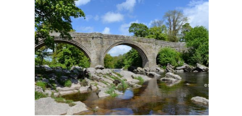
Kirkby Lonsdale is a small, picturesque village on the edge of the Lake District. It sits on the banks of the River Lune, which is straddled by an historic, three-arched bridge known as the Devil’s Bridge. The legend behind this evocative name has several variations; the version that I was told is that one night, a cow belonging to an old farmer’s wife wandered away from the barn and across a shallow expanse of the River Lune. Nothing the farmer’s wife did could coax the cow to cross back over. Suddenly, the Devil appeared before the woman, offering her a deal. In exchange for building a bridge so she could retrieve her cow, the Devil would get the soul of the first one to cross the bridge. The woman agreed to this deal. Once it was finished, the woman tossed a loaf of bread across, which her little dog chased after, making it the first one to cross the bridge. Enraged at being cheated, the Devil disappeared in a cloud of smoke. And thereafter, the bridge became known as the Devil’s Bridge.
Versions of this legend are attached to many bridges and structures across England and Europe; it is archetypal. But what is the history of this bridge, and how did it attract such a legend?
We don’t know just how old the bridge is; however, sources seem to suggest that it dates back to at least the 13th century. Some historians believe that the bridge may have been built by the same mason’s who worked on the construction of St Mary’s Church in Kirkby Lonsdale, which dates from the 12the century.
A survey of the county – then Westmorland, now Cumbria – published in 1936 concluded that though a bridge had undoubtedly spanned this expanse of river since the 13th century, the three-arch form of the current bridge is more reminiscent of late-15th or early-16th century design. Whether the original bridge was damaged by an accident, weather event, or just passage of time is unknown; but for whatever reason, the bridge must have been considered unsafe, yet important enough to rebuild.
In 1275, during the reign of King Edward I, a pontage – a tax for repairs – was issued for the bridge. Another charter for pontage was issued in 1365:
‘Richard de Wisebeche, vicar of the church of Kirkeby in Lonesdale, and Thomas Banes, of pontage for six years in aid of the repair of the bridge of Kirkeby in Lonesdale on things for sale passing by or under that bridge between the priory of Horneby and Gratrehals.’
In 1574, Christopher Saxton began a cartographical survey to create the first county maps of England, which he published in 1579 as the ‘Atlas of the Counties of England and Wales.’ On the map of the County of Westmorland, you can just make out KIRKBY LAUNSDALE, along with a small representation of our bridge.
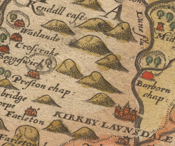
When William Camden wrote his topographical and historical description of England, ‘Britannia,’ which was published in 1586, he included a very brief description of the bridge:
‘… The bridge over the river is built of freestone of three ribbed arches, the centre arch is 12 yards from the water.’
In 1663, it appears a stone sundial was installed on the east end of the bridge, bearing the inscription:
‘N : CONSTABL C : LONSDALE WAR”; “FEARE GOD HONER THE : 1663’
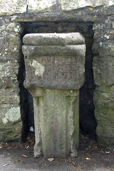
You will notice that there is no reference to the devil in any of these accounts; in fact, before the 19th century, it seems to merely have been known as the Kirkby Lonsdale Bridge. The first reference to the Devil in connection with the bridge was in ‘A Guide to the Lakes’ by Thomas West, published in 1778:
‘The bridge is the most lofty, strong, ancient, and striking to the eye of a stranger, of any I have yet seen. It is built of freestone, has three arches (two large and one smaller) the height from the surface of the water to the top of the centre arch, except in a flood, is about twelve yards. The arches are of the ribbed sort, which makes the appearance the more grotesque. There is no memorial of its foundation – a negative argument of its vast antiquity. We were indeed amused with one anecdote of its founder, which seemed to be a remnant of the ancient mythology of the north, and one instance, among many, of easily accounting for any thing that is marvellous. The country people have a tradition that it was built by the Devil one night in windy weather; he had but one apron full of stones for the purpose, and unfortunately his apron-string breaking as he flew with them over Casterton-fell, he lost many of them out, or the bridge would have been much higher.’
It wasn’t until well into the 19th century, though, that the name ‘Devil’s Bridge’ seems to have stuck. The 19th century saw the advent of Romanticism; many superstitions and legends were born and promulgated during this time.

